

The journey of the mother of all
Philippine maps back home began four
years ago
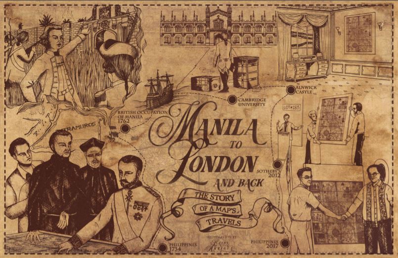
In 2014, an information technology entrepreneur was on the phone bidding in an auction in London, England, more than 10,700 km. away from Manila. Eventually, he won the bid for the 1734 Murillo Velarde map or the Carta Hydrogaphica y Chronographica de las Islas Filipinas, an heirloom of the 12th Duke of Northumberland, Ralph Percy. After winning the map at the London Sotheby’s, Velarde sent a copy to the team that would argue before the Permanent Court of Arbitration (PCA) at The Hague in the Netherlands on the Philippines’ claim on the South China Sea. The team included Supreme Court associate Justice Antonio T. Carpio The 1734 Murillo Velarde map played a crucial role in winning the Philippines’ case against China’s claim over the South China Sea (West Philippine Sea). This was on July 12, 2016. (see Map rights wrongs: the 1734 Murillo Velarde map). The Philippines now has in its public collections the country’s first and most important scientific map, thanks to the benevolence of Mel Velarde, who donated to the National Museum the map he bought at London Sotheby’s for US$273,000 (P12 million). How did the Murillo Velarde map of 1734 end up in the United Kingdom? An official map of the Spanish empire, it was commissioned by Philippine Governor General Fernando Valdes y Tamon (1729-1739) and was designed by Jesuit priest Pedro Murillo Velarde, drawn by Francisco Suarez and engraved by Nicolas dela Cruz Bagay in eight copper plates. Madee in Manila, the map shows the maritime routes from Manila to Spain and to New Spain (Mexico and other Spanish territories in the New World), an important route for the Galleon Trade. In the conflict between England and France from 1756 to 1763 (known as the Seven Years War), the Philippines found itself embroiled in the battle when Spain allied itself with France. As a territory of Spain, Manila was vital to the Spanish empire and was very much on the British’ radar. Appearing in Manila Bay and taking the Spanish forces by surprise on Sept. 23, 1762, the British fleets finally captured Manila on Oct. 6, 1762 after 12 days of fighting. In less than two days, Manila’s wall was breached, its citizens raped, tortured and killed, and its treasures looted. Among the looted artifacts was the set of eight copper plates of the 1734 Murillo Velarde map. Brigadier General William Draper, the commander of the British fleets, brought these copper plates to London and donated them to Cambridge University, his alma mater. The University then ran several new prints of the map. One of these maps was acquired by the then Duke of Northumberland who brought it home at Alnwick Castle. There, it stayed for more than 200 years. Sadly, the copper plates were later melted by the British to print their admiralty charts.
Lot #183. In May 2012, a huge portion of the properties of the present day Duke of Northumberland was damaged by a severe flood. Repairing the damage entailed millions of pounds. By 2014, the Duke announced the sale of family heirlooms to raise funds to cover the cost of repairs. Among those to be auctioned off at Sotheby’s was the 1734 Murillo Velarde map estimated between US$32,000 to US$48,000. The map, Lot #183, was put up for bid at the auction house and was eventually won by Mel Velarde at the price of US$273,000. Almost three years after the auction, the celebrated map came home on Apr. 29, 2017. It was formally turned over to the Philippine government on June 12, 2017, the country’s 119th anniversary of
Independence from Spain.

By Mariamme D. Jadloc
illustration by Brent Antigua
Source : https://upd.edu.ph/wp-content/uploads/2019/01/NEW-UPDATE-OCT-DEC2018.pdf