

For a man who relies on favorable odds to remain in business, the fact that the “Mother of all Philippine maps” was auctioned off at Sotheby’s London on his mother’s birthday sounded propitious enough.
And so it was, although the P5 million businessman Mel Velasco Velarde had been prepared to cough up for the 1734 Murillo Velarde map soared to the final hammer price of P12 million after some furious bidding at that Nov. 4, 2014 auction.
For the chief executive officer of the international digital technology company Now Corp. and chair of the Asian Institute of Journalism and Communication (AIJC) who prides himself on being the top taxpayer in 2009, “it was still a lot of money,” but a paltry sum considering the map’s historical, aesthetic and cartographic value.
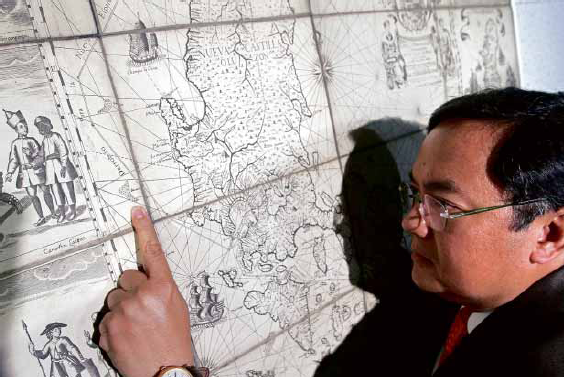
Published in Manila in 1734, “Carta hydrographica y chorographica de las Islas Filipinas” was prepared by the Jesuit friar Pedro Murillo Velarde, and drawn and engraved by indios Francisco Suarez and Nicolas de la Cruz Bagay, respectively. When it came out, the map was universally hailed for its faithfulness to detail at a time when drones, GPS and satellites were yet unheard of.
Before Google Earth
“It became a sensation in Europe because it was very detailed,” said Supreme Court Senior Associate Justice Antonio Carpio during a recent AIJC forum on the maritime dispute in the South China Sea.
“It was the advance party for Google Earth,” Carpio added.
Former Education and Culture Minister Jaime Laya described the 1.2-x-1.5-meter map as “the Holy Grail of Philippine cartography,” as it did not only trace the maritime routes from Manila to Spain and Mexico, but also had 12 panels, six on each side, that showed the ethnic groups in the Philippines in the 18th century, the country’s fauna and flora, as well as the interior topography of colonial Manila.
Its most valuable and relevant feature, however, lies on the map’s upper left section, west of the coastline of Luzon: the cluster of land mass called “Bajo de Masinloc” and “Panacot,” what is now known as Panatag or Scarborough Shoal, which is irrefutable proof that as early as the 1700s, the disputed shoal has been part of the Philippine territory, Velarde said.
Concocted nine-dash line
“As Justice Carpio said in his lecture, none of the islands drawn in this Murrillo-Velarde map ever appeared on China’s maps since centuries ago—only in recent history when China concocted the nine-dash line,” the businessman said in an e-mail interview with the Inquirer.
That was why the jacked-up price was worth every cent, Velarde said. “If you have the money … what loss of value could haunt you forever, if the other party, say a Chinese businessman, won it for China?”
He added: “Ninety-five percent of my money comes from this nation. I wanted to contribute something back (beyond) cash.”
The map is also a collectible relic to the man who describes himself as a collector, “not of art pieces but of books: I have a library of more than 10,000 titles. You see, in the early ’80s, I worked for a bookstore in Glendale, where I got paid half in cash, half in books.”
Velarde, who named math and history as favorite subjects in his younger days; business and economics, “in (his) hungry days” now considers neuroscience his latest interest.
“I enjoy new sciences that debunk all forms of dogmas and falsehoods sprinkled in history, religion, morality, politics, philosophy, etc.,” he said, citing one of the “hundreds of compelling epiphanies embedded in the Murillo Velarde map.”
“The cartouches on the map showed realities of an (advanced) civilization even prior to Spanish times …. Ours was a civilization that possessed and manifested universal, nonculture specific values, showing that our ancestors had knowledge of right and wrong.”
New personal directions
Acquiring the map then became as much a personal goal as it was a business decision. “I’m in the technology business … and I endlessly admire the collaboration of skills and technology between Father Murillo Velarde and his team,” Velarde said.
He added: “At 50, I think the Murillo Velarde map revealed and signaled new personal directions for me—which is to use technology and the best it offers for education.”
Velarde recalled that he was in the middle of his “research on neuroscience, religion and morality,” when the map emerged in the air, thanks to Carpio who told him about the auction.
Carpio had approached several private museums about the possibility of them bidding for the map, but they cited lack of funds, so the justice approached him, Velarde said. Their deal was that the businessman would pay the winning bid—around P5 million they had reckoned, from the stated starting bid of about P1.5 million—but that he would resell it at cost to the National Museum once that agency had the budget for it.
But with the hammer price settling at P12 million, Velarde knew there was no way he could get reimbursed for the amount. He would have to treat the map as a donation, a complete turnabout for what was once a war booty that the British carted off after their occupation of Manila from 1762 to 1764.
In what became known as the First Rape of Manila, the British looted the capital of valuable documents, including the copper plates of the Murillo Velarde map, which was why there were very few copies of it, Carpio said in the AIJC forum on Asia’s maritime dispute.
Harry Potter setting
The copper plates themselves were later melted down to be used by the British for their admiralty maps, Carpio added. For the next 250 years, the original map was kept by the duke of Northumberland in the Alnwick Castle, the same castle used as Hogwarts School of Witchcraft and Wizardry in two Harry Potter movies.
“I think it now has the force of the Hogwarts school,” Carpio said in jest.
It was a joke that Velarde might have taken seriously, considering his other plans for the map that, in the meantime, stays with Sotheby’s in London as a matter of convenience, should the International Tribunal for the Law of the Sea, located at The Hague, need it during the hearings.
Donating the map to the National Museum is a done deal, Velarde said, the only condition being that “the government would take care of it and allow anyone to see it, to help explain its value and our incontrovertible ownership of every inch of these islands.”
The man has grander plans beyond the donation. “Let me tell you, every Chinese child since 1935 was taught in school that these contested islands were owned by China for centuries … We must match the indoctrination, propaganda and brainwashing of their youth with our own truth seeking and truth dissemination among our youth. A P12-million map without the accompanying follow-through programs would make that map a mere wallpaper!”
Grand reunion
Among the planned events is “a grand reunion of 17th century towns and cities included in the Murillo Velarde map this coming July … with local governments or schools that show active participation in our projects targeted to receive a life-size certified copy of the map.”
A website, www.murillovelardemap.com, would also be launched, while plans to donate copies of the map with accompanying educational materials to all schools, cities and municipalities are being fine-tuned.
Updating the map is an option as well. “We want to produce a 21st century digital map using the latest technologies … to add new icons, like the tarsiers in Bohol, the rodent fossils found in Callao Cave in Cagayan, and so on,” Velarde said.
“Being a former Unesco commissioner for eight years and chair of the Committee on Science and Technology, I hope the map of Murillo Velarde would rekindle our patriotism and vigilance,” Velarde said. TVJ
http://globalnation.inquirer.net/124287/mother-of-all-ph-maps-coming-home#ixzz3cLeoAZaP