


The Philippine government will be submitting to the United Nations Tribunal on the Law of the Sea in The Hague this week an almost 300-year-old map of the Philippines showing the disputed Scarborough Shoal being part of Philippine territory as far back as three centuries ago.
The map debunks the so-called nine-dash-line China has been using as proof of its claim over the South China Sea. It also locates Scarborough Shoal, then known as “Panacot,” also called “Panatag” by Filipinos, off the shores of Luzon, then known as Nueva Castilla. Scarborough Shoal has been a source of conflict between the Philippines and China.
The Jesuit priest Pedro Murillo Velarde had the map published in Manila in 1734. It surfaced in 2012 among the possessions of a British lord, who put it up for auction at Sotheby’s in London, where Filipino businessman Mel Velarde bid and got it for £170,500 ($266,869.46 or P12,014,463.09).
The first certified true copy of the map has been reserved for Malacañang. Velarde will personally present it to President Benigno Aquino 3rd on June 12, the anniversary of Philippine independence.
How Velarde, president and chief executive officer of Information Technology-based Now Corporation, acquired the map that had lain among the treasures of one of England’s most prominent families for more than 200 years is like something out of the movies. In fact, the wizard Harry Potter even makes a cameo appearance in the story.
Velarde is yet to find out if he is related to the Jesuit priest, although a possible connection was one of the motives for his pursuit of the artifact.
He said Supreme Court Justice Antonio Carpio, a long-time friend, suggested to him sometime in October last year to bid for the Murillo Velarde map. Velarde recalled that Carpio’s convincing line was: “You know, man, you’re a Velarde.”
Carpio, who has been conducting lectures debunking China’s claim to almost the entire South China Sea, calls the Murillo Velarde map the “Mother of all Philippine maps.”
Local public and private museums declined to take part in the Sotheby’s bid. The National Museum was interested but didn’t have the money, so the plan was for Velarde to buy the map and sell it later to the National Museum.
The Murillo Velarde map measures 1,120 mm by 1,200 mm. The Sotheby’s catalog carried a description of the map by Filipino historian and biographer Carlos Quirino: “Murillo Velarde’s map of the Philippines is a landmark in the depiction of the islands, and the first scientific map of the Philippines. It is flanked by two pasted-on side-panels with twelve engravings, eight depicting native costumed figures, a map of Guajam (Guam) and three city or harbor maps, notably Manila.”
The map was among 80 heirlooms that the current Duke of Northumberland, Ralph George Algernon Percy, decided to auction off after a devastating flood hit Northumberland County in April 2012.
Newspaper reports said heavy rains had “caused a culvert on the Duke of Northumberland’s land to collapse. Many residents were evacuated and some homes demolished after the foundations were damaged.”
Although the Duke’s estate did not own all the affected homes, he provided urgent help for his neighbors. The flood left him with a £12 million bill for repairs, hence the need to auction off his family’s collection.
As a bit of trivia, the Duke owns the vast Alnwick Castle, which has been featured as Hogwarts School of Witchcraft and Wizardry in the first two Harry Potter films.
Sotheby held the first auction on July 9, 2014 and the second on Novenber 4, 2014, both in London.
It was in the November auction that the Murillo Velarde map, called Carta Hydrographia y chorogphica de las Ylas Filipinas, Manila 1734, was included under Lot 183.
The Murillo Velarde map names two Filipinos as responsible for the map–Francisco Suarez who drew it and Nicolas de la Cruz Bagay who engraved it.
Historian Ambeth Ocampo wrote in his column in the Philippine Daily Inquirer, “The Murillo Velarde map of 1734 is quite rare, with [fewer] than 50 known copies to exist in the entire universe.”
Velarde registered to participate in the auction through an agent. He had participated in auctions in person before but his acquisition of the map last November was his first bid by phone.
The Sotheby’s auction took place at 9 p.m, Manila time while Velarde was in a Resorts World steakhouse for his mother’s 78th birthday dinner.
Velarde described the bidding, which lasted only for three to four minutes, as “furious.”
He was on the phone before Sotheby’s put Lot 183 on the auction block, and noted that in other lots, it was over after two to three bids.
Bidding for the map started at £30,000. He started to bid through his agent, thinking that he could go as high as £80,000.
Velarde said he could hear “30,000 pounds,… 40,000 pounds… 50,000 pounds. Fifty-five, sixty.” He said, “It seemed like so many were bidding.”
When the bidding reached £80,000, Velarde said he paused for a few seconds to decide whether to stop. The exchange rate was P68 to £1. He knew that the National Museum could allot only P5 million to buy rare items.
Then images of the Chinese occupying the contested islands in the Spratlys came to mind, according to him, and he decided to proceed.
“Pansariling away na, nagiging personal na sa akin [It became a personal crusade],” Velarde said. He eventually paid more than double the amount he thought he was willing to part with: £170,500.
When you buy a car, he said, you have something to compare it with. Not in the case of an old map. But Velarde also thought of the possible implications later, knowing that there is a pending case before the UN International Tribunal on the Law of the Sea against China. “You need some evidence.”
Velarde said he is thankful the auction was not held in Shanghai or Macau, where the map could have attracted Chinese bidders and the price would have been much higher.
Now that Velarde owns the map, the National Museum has informed him it has no funds to buy the map this year, and that there was some uncertainty about funds next year. Velarde decided to donate the map instead.
Why is he doing it?
“In a true-to-life movie, there’s a part for everybody. There’s a bully in the neighborhood. He already took over our land. We have soldiers in the Spratlys. Naka-standby lang sila [They’re just on standby there],” Velarde said.
“Then, this map is owned by a Duke in a Harry Potter castle. It’s like you wanting to play your part in the movie,” he added.
Velarde said he hopes to meet with the Duke of Northumberland someday. His children want to come along, not really for the Duke, who comes from a 700-year-old English aristocracy and is the fourth-largest landowner in the United Kingdom. They are excited to see the room where Harry Potter had his first flying lessons.
VERA Files is put out by veteran journalists taking a deeper look at current issues. Vera is Latin for “true.”
The post 300 -yr old map to boost Manila’s case appeared first on The Manila Times Online.
Source : http://allpinoynews.com/300-yr-old-map-to-boost-manilas-case/
By Coconuts Manila June 8, 2015 / 14:10 PHT

Will the map prove our claim?
“The Philippine government will be submitting to the United Nations Tribunal on the Law of the Sea in The Hague this week an almost 300-year-old map of the Philippines showing the disputed Scarborough Shoal being part of Philippine territory as far back as three centuries ago,” reports Ellen T. Tordesillas of the VERA Files via InterAksyon.com.
The report noted: “The map debunks the so-called nine-dash-line China has been using as proof of its claim over the South China Sea. It also locates Scarborough shoal, then known as “Panacot,” also called “Panatag” by Filipinos, off the shores of Luzon, then known as Nueva Castilla. Scarborough shoal has been a source of conflict between the Philippines and China.”
The map was obtained by Filipino businessman Mel Velarde from a Sotheby’s auction in London for GBP£170,500 (US$266,869.46 or PHP12,014,463.09).
The Jesuit priest Pedro Murillo Velarde had the map published in Manila in 1734. It was among the possessions of the current Duke of Northumberland, Ralph George Algernon Percy, who decided to auction it off (along with other properties) after a devastating flood hit Northumberland County in April 2012.
Velarde the businessman doesn’t know yet if he is related to the Velarde Jesuit priest.
Photo: Detail from Sotheby’s flyer
source: http://manila.coconuts.co/2015/06/08/ph-present-300-year-old-map-proving-territorial-rights-un
(philstar.com) | Updated June 8, 2015 – 6:18pm
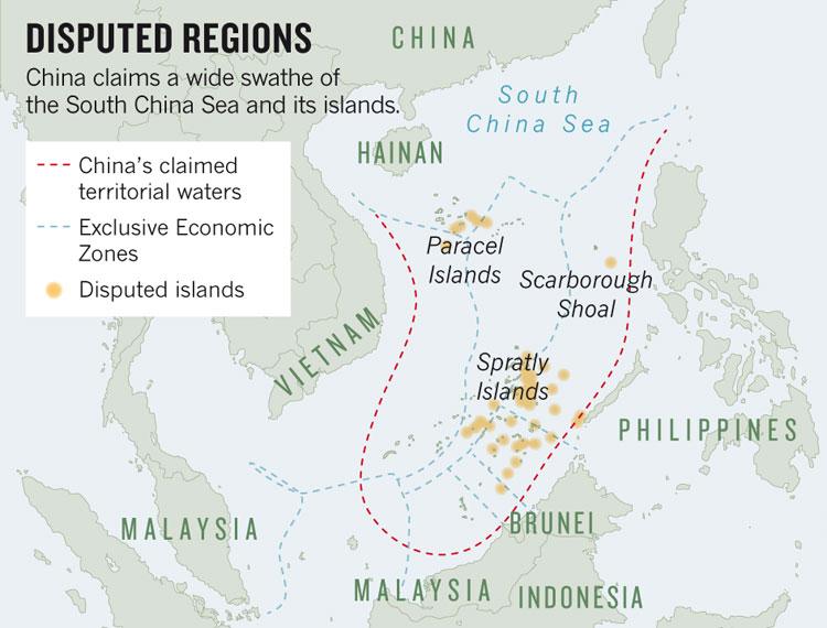
South China Sea areas claimed by the Philippines such as the Scarborough Shoal and Spratly Islands are also being claimed by China through the nine-dash line shown in red marks. Council on Foreign Relations
MANILA, Philippines – The submission of a 300-year-old map to the international tribunal will strengthen the case filed by the Philippines against China’s territorial claim, Malacañang said Monday.
“China’s claim is about historical title. This old map would certainly present the side of the Philippines when it comes to any historical basis,” Presidential Spokesperson Edwin Lacierda said in a press briefing.
Lacierda said the Philippines has a “strong” case against China, which is claiming virtually the entire South China Sea.
The VERA Files reported that Filipino businessman Mel Velarde won an auction and got the map published by Jesuit priest Pedro Murillo Velarde in 1734.
Debunking China’s so-called nine-dash-line claim, the Murillo map indicates Scarborough shoal, known in the past as “Panacot,” which is among the contested areas in the South China Sea.
The Philippine government will submit the map to the United Nations Tribunal on the Law of the Sea in The Hague this week while its certified true copy will be presented to Malacañang and President Aquino on Independence Day.
Headlines ( Article MRec ), pagematch: 1, sectionmatch: 1
Lacierda reiterated that the Philippines seeks to resolve its territorial dispute with China through peaceful means such as international arbitration.
The Palace official, however, acknowledged that China has refused to participate in the arbitration proceedings initiated by the Philippines.
Despite the territorial row, Lacierda said thePhilippines maintains good ties with China.
“If you’re going to limit yourself only to the South China Sea, certainly it will color your perspective,” Lacierda said.
“We have established good relations with China and we are friends,” he added.
Published on 9 June, 2015 – 17:16

The Philippine government will be submitting to the United Nations Tribunal on the Law of the Sea in The Hague this week an almost 300-year-old map of the Philippines showing the disputed Scarborough Shoal being part of Philippine territory as far back as three centuries ago.
The map debunks the so-called nine-dash-line China has been using as proof of its claim over the South China Sea. It also locates Scarborough shoal, then known as “Panacot,” also called “Panatag” by Filipinos, off the shores of Luzon, then known as Nueva Castilla. Scarborough shoal has been a source of conflict between the Philippines and China.
The Jesuit priest Pedro Murillo Velarde had the map published in Manila in 1734. It surfaced in 2012 among the possessions of a British lord, who put it up for auction at Sotheby’s in London, where Filipino businessman Mel Velarde bid and got it for £170,500 ($266,869.46 or P12,014,463.09).
To read the full article, please click here
Published on Jun 10, 2015
This video has other parts: PART (2/3) PART (3/3)REAKSYON | Sa patuloy na sigalot ng Pilipinas at Tsina kaugnay ng pagmamay-ari ng West Philippine Sea, isinapubliko kamakailan ang “Murillo Velarde Map” na pinakamatandang mapa ng bansa (300-taong-gulang). Ayon sa nakabili ng mapa na si Mel Velarde, may kapasidad daw ito na pasinungalingan ang “9-dash line” ng Tsina na ginagamit nila sa kanilang mga “territorial claim.” Panoorin ang panayam ni Luchi Cruz-Valdes. (Video uploaded by James Relativo; Manuscript edited by Joey Hernandez. For any concerns, you may E-Mail us at newsfiveeverywhere@gmail.com)
Philippines government to take 1734 document to UN tribunal to support its demand that China leaves the Scarborough Shoal
A 281-year-old map from the collection of an English duke is to be put forward by the government of the Philippines to support its claim to islands in the South China Sea that are presently being fortified by China.
The Philippines government has said it will submit the map, drawn up in Manila in 1734 by Pedro Murillo Velarde, a Jesuit priest, to the United Nations Tribunal on the Law of the Sea in The Hague as soon as this week, according to the Vera Files website.
The map shows islands that are now known as Scarborough Shoals, marked as Panacot, as part of Philippines territory. They are shown around 120 miles off the west coast of the main Philippine island of Luzon.
 The map shows islands that are now known as Scarborough Shoals, marked as Panacot, as part of Philippines territory (Library of Congress)
The Philippine government is calling on the UN to recognise its claim to sovereignty over the islands and to call on Beijing to withdraw.
The map was sold at Sotheby’s auction house in London in November at the request of the Duke of Northumberland.
The duke sold the map, along with around 80 other family heirlooms, after serious flooding affected his properties in April 2012. Media reports suggested that the duke faced a repair bill for £12 million after the waters subsided.
The map was put up for auction on November 4, with the Sotheby’s catalogue describing the 44-inch by 47-inch engraved map as being “the first scientific map of the Philippines” of its time.
With light browning along the creases, the map is flanked by a series of 12 engravings depicting people in native costumes, a map of the island that is today known as Guam and smaller maps of cities and harbours in the Pacific.
Sotheby’s estimated that the item would sell for between £20,000 and £30,000, but it quickly outstripped those predictions and was eventually sold for £170,500 to a Filipino businessman.
 Panacot, circled, in the Murillo map (Library of Congress)
Mel Velarde, president of an information technology company called Now Corporation, said he first became interested in the map because he shared a family name with the priest who had first published it.
He told the Vera Files that his interest increased when he realised that it “proved” the Philippines’ claim to the islands.
The bidding quickly reached the £80,000 limit that Mr Velarde had initially set himself.
But after a “vision” of Chinese soldiers occupying the islands, Mr Velarde said it “became a personal crusade” to buy the map because the Philippines’ claim needs to be backed up by evidence.
Asked why he had paid so much for the map, Mr Velarde said, “There’s a bully in the neighbourhood. He already took over our land.”
 The Philippines accused China of seizing the islands in 2012
Mr Velarde has decided to donate the original map to the National Museum but has had a number of copies printed. He will present one of those copies to Benigno Aquino, the president of the Philippines, on June 12, the anniversary of the nation’s independence.
Another copy will be delivered to the UN as Manila seeks arbitration in the territorial dispute.
The Philippines accuses China of seizing the islands in 2012, when ships of the two nations were involved in a stand-off. When the smaller Philippine force had to withdraw, the Chinese occupied the islands.
In January 2013, the Philippines requested international arbitration in the case and, the following year, submitted a 4,000-page dossier to support its claim of sovereignty.
Beijing has ignored requests to take part in arbitration procedures.
THE Philippines is scheduled this week to submit a 300-year-old map to the international tribunal, which will bolster its case against China’s territorial claim of the South China Sea, the Malacanang said Monday, June 8.
“China’s claim is about historical title,” said presidential spokesperson Edwin Lacierda in a press briefing. “This old map would certainly present the side of the Philippines when it comes to any historical basis.”
Known as the Murillo Velarde map and originally called “Carta Hydrographica y Chorographica de las Islas Filipinas” was first published in 1734 in Manila by Fr. Pedro Murillo Velarde, a Jesuit priest.
Lacierda said the map will strengthen the Philippines’ arbitration case and debunk China’s so-called nine-dash-line claim, which it has been using to help prove its claim.
At the time the map came out, it was praised for its detail.
“It became a sensation in Europe because it was very detailed,” said Supreme Court Senior Associate Justice Antonio Caprio at a recent Asian Institute of Journalism and Communication forum regarding the dispute, the Philippine Daily Inquirer reported.
“It was the advance party for Google Earth,” Carpio added.
Filipino businessman Mel Velarde, who purchased the map at a Sotheby’s auction for P12 million, will present a certified true copy of it to Philippine President Benigno Aquino III on Friday, June 12.
The map will be submitted to the United Nations Tribunal on the Law of the Sea in The Hague in the Netherlands this week.
Velarde said the map’s most valuable and relevant feature is found on the upper left section where a cluster of land mass called “Bajo de Masinloc” and “Panacot” – now known as Panatag or Scarborough Shoal – located west of the Luzon coastline. The cluster is irrefutable proof that the disputed shoal has been part of Philippine territory, Velarde added, according to Inquirer.
“As Justice Carpio said in his lecture, none of the islands drawn in this Murrillo-Velarde map ever appeared on China’s maps since centuries ago – only in recent history when China concocted the nine-dash line,” Velarde said in an email to Inquirer.
Despite the tensions resulting from the dispute, Lacierda said the Philippines and China remain friends.
“Just to be clear, we have no conflict with the Chinese people. Our conflict, for instance, our differences are with the approach of the leadership in dealing with the South China Sea. But on whole, with respect to the Chinese people, we continue to establish good relations with them. And we certainly look forward to a better relations with China,” Lacierda said, according to ABS-CBN News.
He added that the relationship of the two countries is not wholly based on the territorial conflict, and that people should consider more than just the issue when examining their relations.
“If you are going to limit yourself only to the South China [Sea] issue, certainly, it will color your perspective. But if you look at it from a broader perspective where we have established good relations with China and we are friends – the Chinese people are here, Filipinos are there,” Lacierda said. (With reports from ABS-CBN News, CNN, Inquirer and Philstar)
Posted at 06/10/2015 5:16 AM
The businessman who bought what has been dubbed the “Mother of all Philippine maps” sees his purchase as part of duty to the country. More on Mel Velarde and his priceless acquisition in this report. – ANC, The World Tonight, June 9, 2015
Source : http://www.abs-cbnnews.com/video/lifestyle/06/09/15/why-businessman-bought-old-philippine-map
By Alex Murillo Ho, CNN Philippines
Updated 22:50 PM PHT Tue, June 9, 2015

Metro Manila (CNN Philippines) — A most significant, most systematic map of the Philippines almost three centuries ago.
This was how Professor Ferdinand Llanes of the University of the Philippines in Diliman (UP Diliman) describes the “Murillo map” which was recently bought by a Filipino businessman to bolster the country’s claim over the disputed Scarborough or Panatag Shoal.
Llanes, a former commissioner of the National Historical Commission of the Philippines (NHCP) and former head of the UP Department of History, told CNN Philippines on Tuesday (June 9) that the 281-year-old map was the most reliable map of the Philippine islands during the 18th century — as it was based on travel accounts and old cartographic records of British, Italian, Dutch, Portuguese and French explorers those times.
Llanes said it was made by the Jesuit priest, Pedro Murillo Velarde (Velarde was his middle name) — who was himself a skilled cartographer or map maker — after travelling around the country and its coasts to strengthen his work.
It was so detailed that the map even depicted sketches of Filipino culture and life along its edges, Llanes said.
He added that even the engraver of the map’s plate was a Filipino named Nicolas Bagay.
“It was the map officially recognized the Spanish crown,” according to Llanes.
He cited that the territories outlined in the map were uncontested, and in fact, in the Treaty of Paris on December 10, 1898, Spain ceded to the United States the Philippine islands as depicted on the map.
He said this was incontrovertible fact that Bajo de Masinloc — as Panatag Shoal was called then — was part of Philippine territory since centuries ago.
“This is why China’s claim is preposterous.”
He added that history professors and students had always known about the Murillo map, as it was taught in classes, but the recent acquisition of the P12-million map by businessman Mel Velarde rekindled the issue.
The professor explained that compared to Beijing’s claim which were based merely on historical accounts and description of “knowledge of the seas,” the Philippines had a more solid basis in the Murillo artifact, which was a “territorial map.”
He also cited that Supreme Court Senior Associate Justice Antonio Carpio had also raised the point that even the 1949 Constitution of the People’s Republic of China never mentioned the disputed territories as part of the communist regime.
Meanwhile, Professor Xiao Chua of the De La Salle University (DLSU), added that even all the early maps of China up to the early 20th century showed that its southernmost territory was Hainan Island.
“It’s not the nine-dash line that they are saying,” Chua said. “So it means they recognize it even during the time of the emperors. Their territory only extended to Hainan Island.”
CNN Philippines’ Mandy Dalawangbayan and Dariz Ignacio contributed to this report