

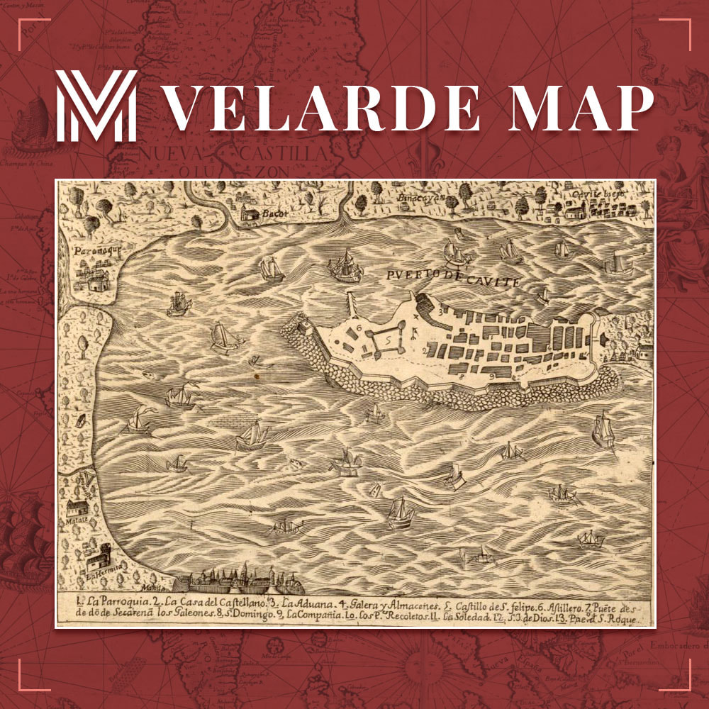
Ang Puerto de Cavite (Port of Cavite) ay isang makasaysayang daungan na may malaki at importanteng ambag sa pambansang kalakalan noong panahon ng Kastila. Ito ang naging pangunahing piyer ng komersyo sa pagitan ng Acapulco, na ngayon ay Mexico at ng Cavite. Ang prosesong ito ng komersyo ay mas kilala sa bansag na Manila-Acapulco Galleon Trade.
Ang Puerto de Cavite ay kilala rin sa tawag na Ciudad de Oro Macizo, o ang “Siyudad ng Ginto.”
Isa sa itinatampok sa vignette ng Mapa ng Murillo Velarde 1734 ang ilustrasyon ng Puerto de Cavite.
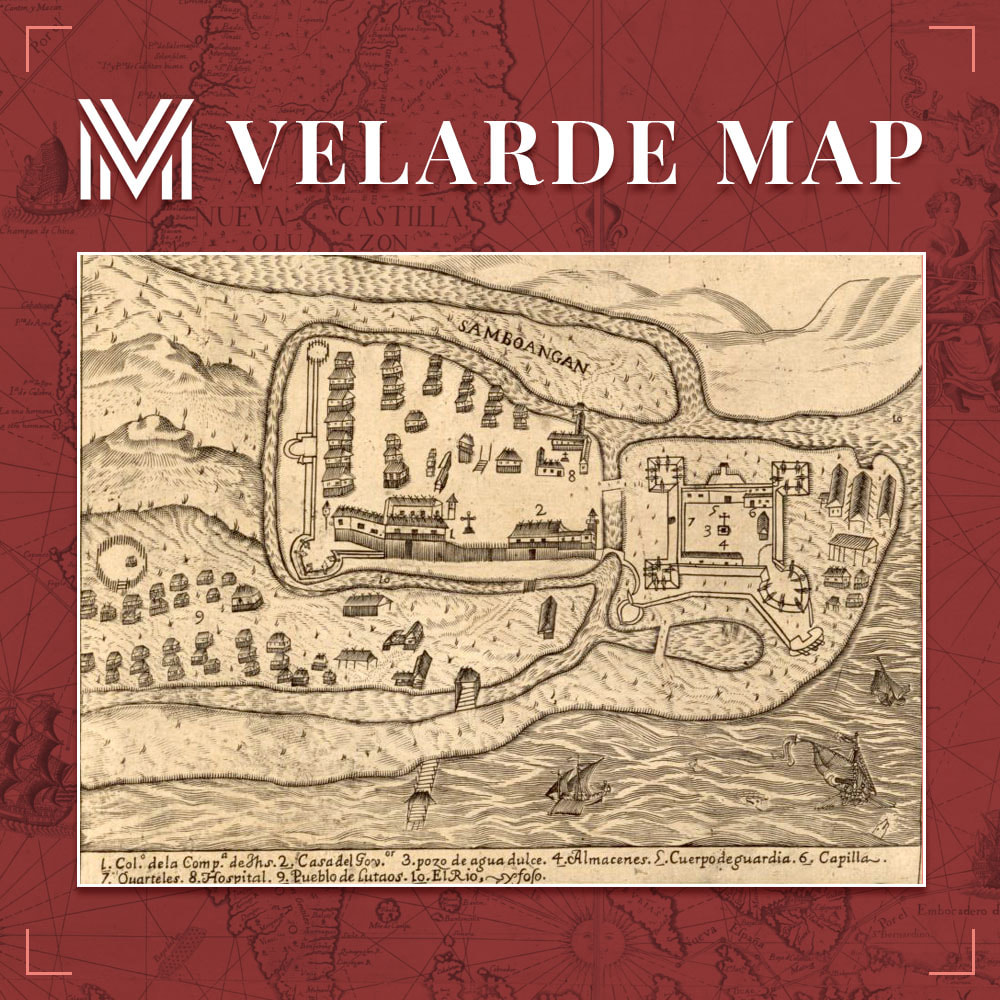
In 1635, Spanish soldiers established Zamboanga on the site of a local village. Its name comes from the Malay word “jambangan,” which means “place of flowers,” and the Zamboangan roadsides are bordered with bougainvillea, orchids, and other tropical flowers. The shrine of Our Lady of the Pillar, Fort Pilar, was established in the 1700s to protect Christian settlers against Moro (local Muslim) pirates, and it currently houses a branch of the national museum.
This vignette of the Murillo Velarde 1734 Map exhibits the very image of Zamboanga and its vicinity from Padre Pedro Murillo Velarde’s vision.
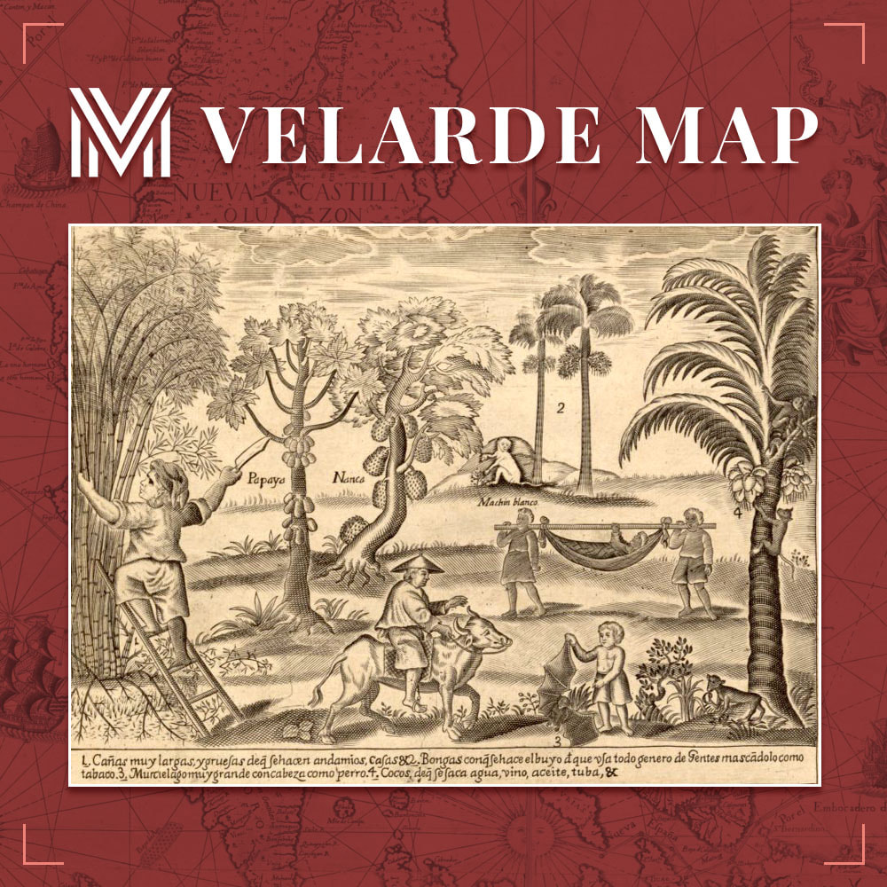
Many anthropologists debate over how agriculture spread to the Philippines, and a precise date of its beginning is uncertain. However, there are indirect indications and other pieces of evidence that anthropologists can use to estimate when and how particular crops arrived in the Philippines. Rice is a major agricultural crop in the Philippines nowadays, and many nations across the world buy rice and other Philippine products.
At the height of the Spanish rule, when businesses were fostered and developed to meet the principal demands of the colonizer Spain and other European consumers for tobacco, sugar, and abaca, traces of modern Philippine agriculture became most prominent to the outside world.
This vignette of the Murillo Velarde 1734 Map exhibits the 17th century rural settings in the Philippines.
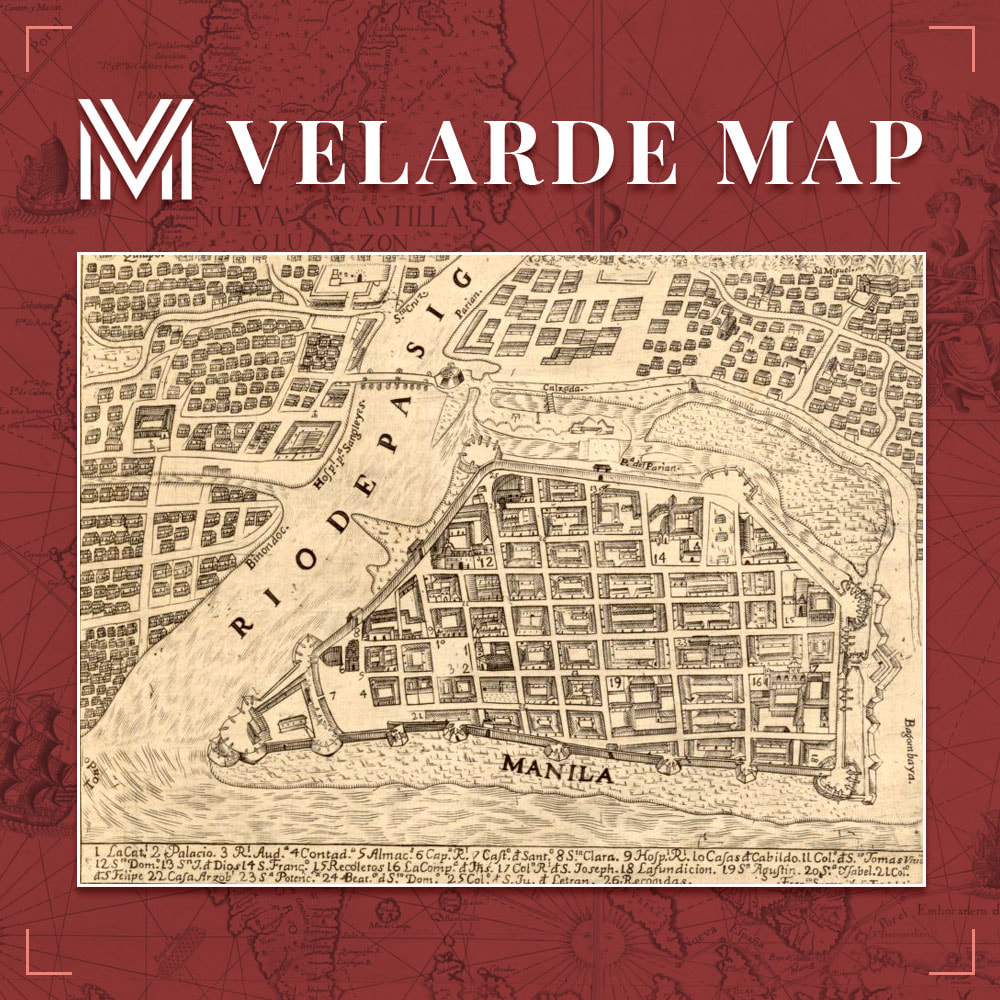
The Pasig River in Manila flows into Manila Bay from Laguna de Bay, the Philippines’ largest lake. It streams north-northwest through Pasig, bisecting Manila, before entering the bay between the north and south ports. It is 14 miles long (23 km). During the Spanish colonial era, the wharves and quays near the river’s mouth served the early interisland commerce. At the time, the Pasig River was home to a vast population of barge and raft dwellers. The shallow, slow-moving creek is presently spanned by nine bridges. It is passable by small ships, but its harbor services have diminished.
This vignette of the Carta Hydrographica y Chorographica de las Yslas Filipinas or the Murillo Velarde 1734 Map exhibits Rio de Pasig, visually interpreted by the Spanish Jesuit priest, Padre Pedro Murillo Velarde.
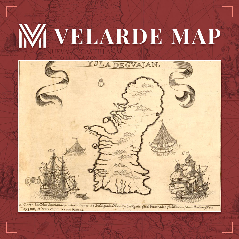
The Island of Guam (Ysla Degvajan) was a stopover for the yearly galleon trade between Mexico and the Philippines. These galleons transported not only items for merchants and other supplies to Guam, but also Filipino soldiers, missionaries, lay assistants, bureaucrats, and even political expatriates and criminals. They were manned by Filipino and Mexican seafarers with a few Spanish superiors.
The records of Filipinos in Guam during the Spanish occupation are said to be sporadic. When Spanish Jesuit Father Diego Luis de San Vitores landed in Guam around 1668, his lay assistant was said to be a Filipino Cebuano named Pedro Calungsod. Calungsod was killed alongside San Vitores when he was martyred. Both San Vitores and Calungsod have been “blessed” by the Catholic Church; this is the first phase toward canonization. Calungsod was canonized in 2012. Early documents indicate that a company of soldiers in Guam in 1690 were Filipino Kapampangans.
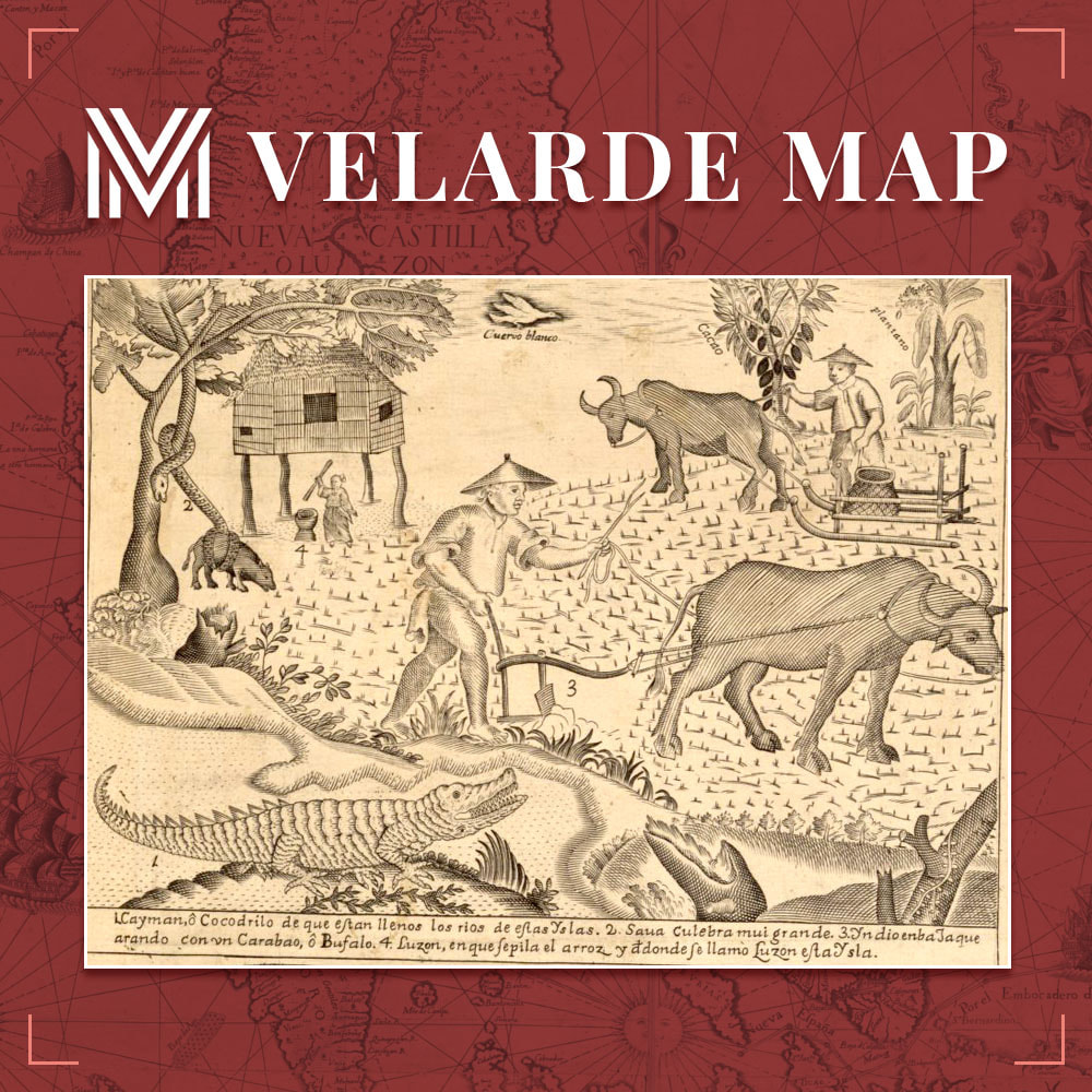
The earliest Spanish colonists discovered fields with flat-bottomed sections and surrounded by small dykes, where rainfall could be collected in the center. Even before the 16th century, farmers had cultivated their rice fields with light plows with only one handlebar, each hauled by a single buffalo.
As early as the 17th century, the Spaniards had allowed the local chiefs or datus to take ownership of rice fields and have them farmed by sharecroppers. The Spanish encouraged Filipinos to plant corn and sweet potato crops from Mexico and Central America.
This vignette of the Carta Hydrographica y Chorographica de las Yslas Filipinas exhibits the rural life of 17th century Filipinos. Jesuit priest and cartographer Padre Pedro Murillo Velarde also illustrated the local Indios along with a few wild and farm animals such as the crocodile, the boa constrictor, and the carabao.
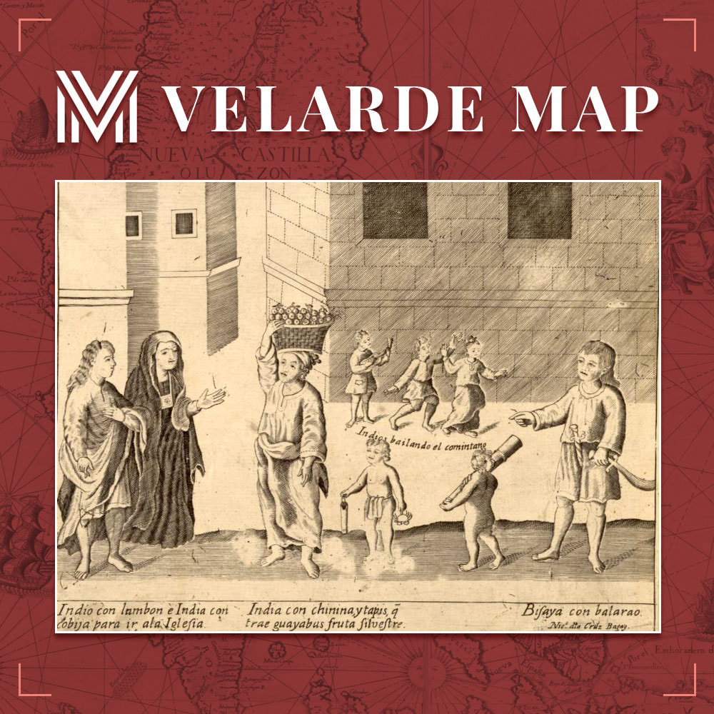
Filipinos of Indian ancestry who have established themselves in the Philippines and have ancestral ties to the country are known as Indian Filipinos. The name refers to Filipinos with pure or mixed Indian lineage who live in the Philippines, the latter as a result of intermarriages between Indians and locals.
The existence of intercultural relations and trade between the Indian subcontinent and the Philippine Islands between the ninth and tenth century B.C. is backed by Iron Age findings in the Philippines. Through the Indianized kingdoms of the Hindu Majapahit and the Buddhist Srivijaya, India had a significant influence on the Philippines’ diverse cultures.
This Murillo Velarde 1734 Map vignette showcases Indian Filipino women in native lambon and kumot.
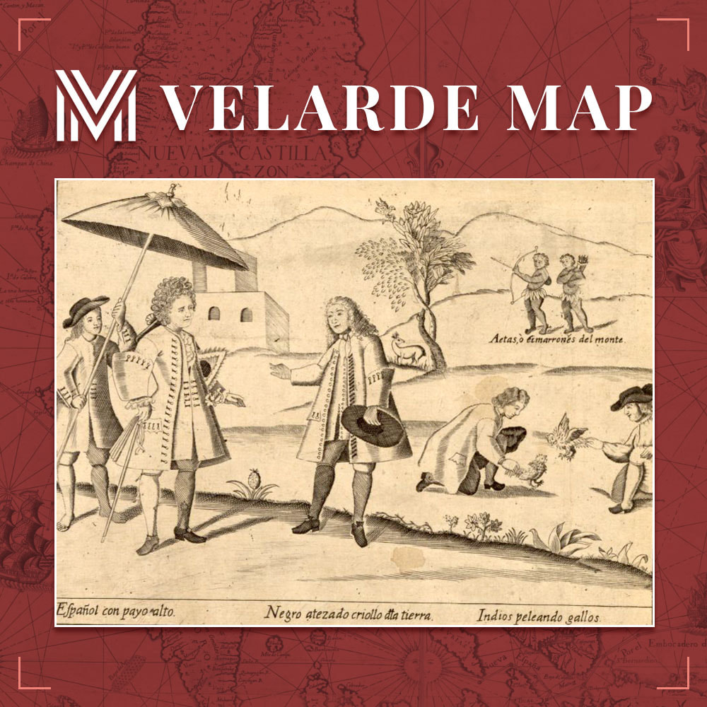
Peninsulares refer to Spaniards born in Spain who resided in the Spanish colonies.
Criollos–full-blooded Spaniards born in the colonies such as the Philippines–were referred to as Insulares.
Indios (for those of pure Austronesian ancestry) and Negritos were two terms used to describe the Philippines’ indigenous peoples.
The Aeta, Agta, and Dumagat are collective designations for groups of Filipino aboriginal communities who inhabit different sections of the Philippines’ island of Luzon. They are thought to be among the Philippines’ first settlers, arriving before the Austronesian migrations.
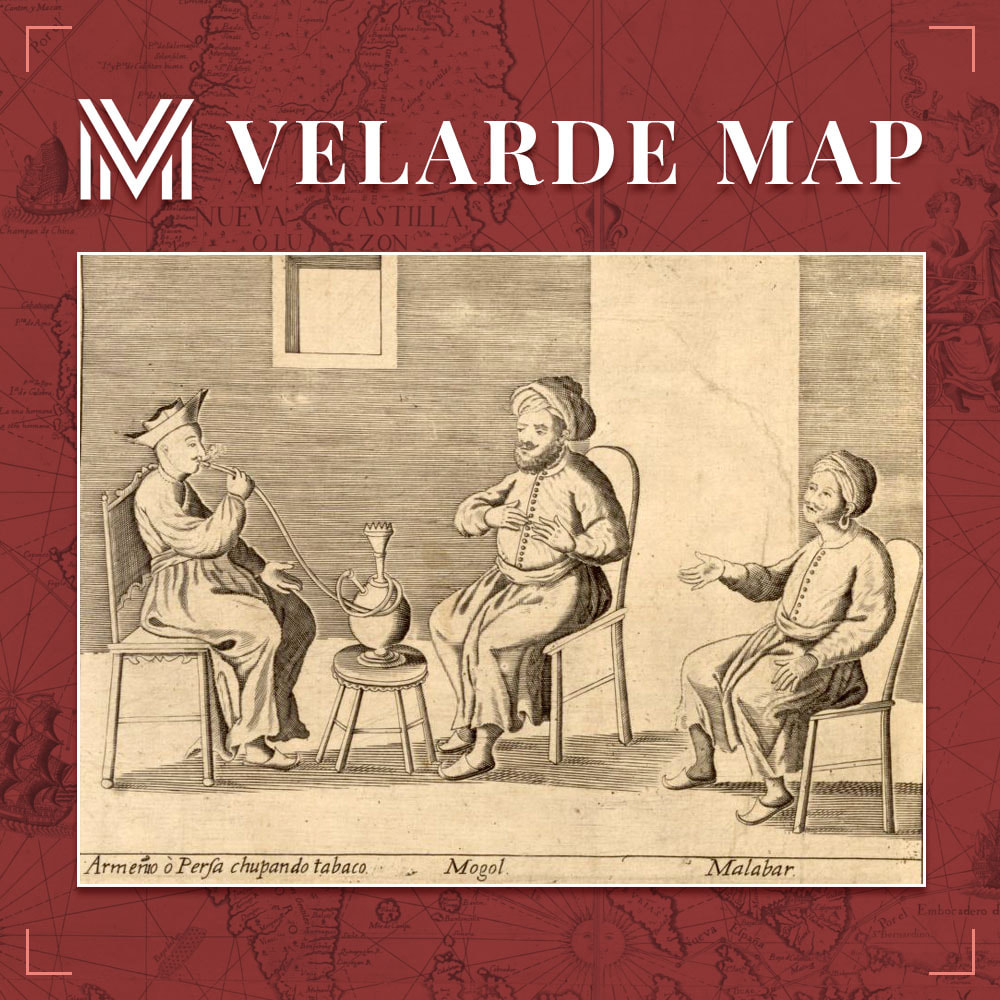
Ang mga Armenian ay isang pangkat etniko ng katutubong kabundukan ng Armenia sa Kanlurang Asya. Sa kasaysayan, ang mga Armenian ay gumanap ng isang makabuluhang papel sa komersyo at kalakalan sa Pilipinas. Nabanggit ng paring Heswita na si Pedro Murillo Velarde na ang mga Armenian, kasama ang ibang mga Kristiyanong Orthodokso ay naroroon sa Maynila noong 1618 pa lamang.
Ang Mughal ay nabibilang sa mga magkakaugnay na kultura at lahi ng India at Pakistan. Sinasabing sila ay nagmula sa iba’t ibang aspeto ng lahing Mongol sa Gitnang Asya.
Ang Malabari ay isang katawagan na ginamit para sa mga Indiano na nagmula sa rehiyon ng Malabar sa bansang India. Sa pamamagitan ng mga emperyo ng Srivijaya at Majapahit, pinaniniwalaang ang mga impluwensya ng bansang India ay unang nakarating sa Pilipinas noong ika-10 hanggang sa unang bahagi ng ika-14 na siglo, batay sa mga kaganapan sa dalawang rehiyong ito.
The historical connection of Japan and the Philippines dates back to the early 8th to 12th centuries CE, and there are earlier accounts stating that it even stretches as far back as the neolithic period. Long before the Spanish conquest, the Japanese were trading with Philippine dynasties, primarily in pottery and gold. Japanese traders, particularly those from Nagasaki, were known to frequently visit the Philippine coasts, bartering Japanese commodities for Filipino items such as gold and pearls, according to historical documents. Shipwrecked Japanese seafarers, pirate merchants, and immigrants eventually settled in the Philippines and intermarried with the locals.
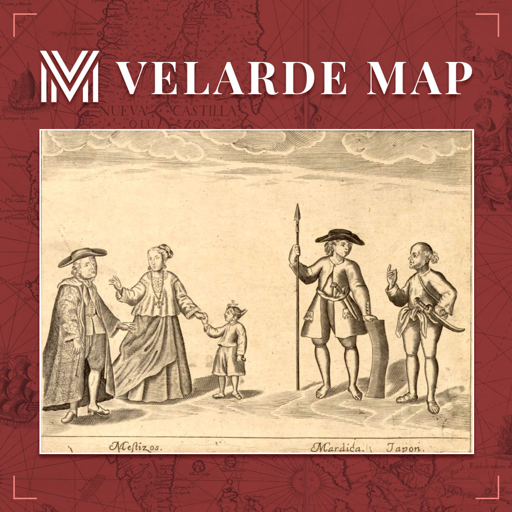
The Mardica people are a group of descendants of liberated slaves who live in the Dutch East Indies (modern-day Indonesia). The Mardicans’ forefathers had been Portuguese slaves in India, Africa, and the Malay Peninsula, and were transported to Indonesia by the Dutch East India Company (VOC), particularly following the 1641 Dutch invasion of Malacca, when Portuguese speakers in the city were abducted.
The Filipino Mestizo in the Philippines, or colloquially “Tisoy,” are settlers who have Filipino and foreign blood. The term “mestizo” is Spanish in origin, and it was initially used in the Americas to refer to persons who were of mixed Native American and European descent.
This section of the Carta Hydrographica y Chorographica de las Yslas Filipinas showcases the three aforementioned groups that lived in the 18th century Philippines: The Mestizos, Mardicans from Ternate and Tidore, and the Japanese or “Japon.”