

News & Updates
Crucial to PH case

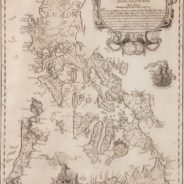
Might this map give the Philippines the upper hand against China in the dispute over ownership of Scarborough Shoal and other islets in the West Philippine Sea? Businessman Mel Velarde recently successfully bid for and acquired a certified true copy of what is known as the Murillo Velarde map, a cartographic sketch of the Philippine archipelago said to have been drawn by Jesuit priest Pedro Murillo Velarde and published in Manila in 1734. The World Digital Library, which carries a downloadable copy of the map, says “it is the first and most important scientific map of the Philippines.” The site further describes the map (formally known as “Carta Hydrographica y Chorographica de las Yslas Filipinas,” Manila 1734, or A Hydrographical and Chorographical Chart of the Philippine Islands) thus: “The map is not only of great interest from the geographic point of view, but also as an ethnographic document. It is flanked by twelve engravings, six on each side, eight of which depict different ethnic groups living in the archipelago and four of which are cartographic descriptions of particular cities or islands. According to the labels, the engravings on the left show: Sangleyes (Chinese Philippinos) or Chinese; Kaffirs (a derogatory term for non-Muslims), a Camarin (from the Manila area), and a Lascar (from the Indian subcontinent, a British Raj term); mestizos, a Mardica (of Portuguese extraction), and a Japanese; and two local maps—one of Samboagan (a city on Mindanao), and the other of the port of Cavite.” Velarde’s copy came by way of a curious provenance: It was among the possessions of a British lord—the Duke of Northumberland, Ralph George Algernon Percy—who, needing money to help residents living in his estate whose properties were damaged by a severe flood, auctioned off some 80 items from his family collection. The prestigious auction house Sotheby’s in London held two auctions of the Duke’s heirlooms; Velarde was able to get the map at the second auction held in November 2014, for £170,500 (around P12 million). More than curious historical value, the map may prove crucial to the case the Philippines has filed against China in the International Tribunal for the Law of the Sea in The Hague, which disputes China’s claim to over almost 90 percent of the South China Sea based on its so-called nine-dash line. China has said its ancient records show indisputable historical ownership of the region, an assertion that many international historians and scholars have questioned. The nine-dash-line claim was made by China only after 1947, and officially presented to the world in 2012. By then, the region had become an international flashpoint, with competing claims by countries such as Vietnam and Malaysia, and in the case of the Philippines, even actual occupation of a number of islands scattered in the area. One tiny detail in the 18th-century Murillo Velarde map appears to debunk China’s position: It shows Scarborough Shoal, from which China drove away Philippine troops in 2012, as already part of Philippine territory at the time the map was drawn. Called “Panacot” in the map, the shoal came to be known as Panatag or Bajo de Masinloc in modern times. In this, the map all but supports the masterly survey of 60 other ancient maps done by Supreme Court Senior Associate Justice Antonio Carpio, which convincingly...
read moreRare, important and significant
I can’t wait to view the 1734 Murillo Velarde map of the Philippines that will be donated to and displayed at the National Museum of the Philippines. It is a rare artifact from England where it had been kept, for over two centuries, in the library of the Duke of Northumberland, the same Duke whose castle was used as the set for Hogwarts School of Witchcraft in the Harry Potter movie series. I saw the notice online at Sotheby’s London, which estimated the sale price within £20,000-30,000, way beyond my budget. It ultimately sold for £170,500, or roughly P12 million—almost six times the estimate. At a Manila auction the day after the sale in London in November last year, an art dealer asked me in a whisper: “Were you the buyer of the Velarde map?” I replied in the negative but was flattered to be counted within a small group of suspects. When CNN asked me to comment on the importance of the map, I said: The map is rare (with less than 50 copies extant in the universe); our National Library and the Lopez Museum have the later “mini” version. This map is important because it will be the second original 1734 Murillo Velarde map in the Philippines. One is in a private collection while this one will be accessible to the public in the National Museum. The map is significant because it not only shows a detailed representation of the Philippines in the 18th century (complete with mountains, hills and waterways), it also comes with charming vignettes that show typical people and scenes from the period. In 1734 the Jesuit Fr. Pedro Murillo Velarde did not have Google Earth or satellite imaging. Yet he was able to draw a very accurate map of the archipelago. The map is noteworthy because it was engraved and signed by Nicolas de la Cruz Bagay, one of the earliest native or Filipino artists on record. The contemporary relevance of the Murillo Velarde map, however, is that it is proof against the China claim to Scarborough Shoal. The Chinese have been saying that they have historical rights to Scarborough but cannot produce a Chinese map to support their claim. The Murillo Velarde map shows what we know today as “Panatag” within the territory of Spanish Philippines when it was known as “Panacot” (Threat). Panacot is not only aptly named in the map; it is also located near “Lumbay” (Grief) and “Galit” (Anger). The repatriation of the Murillo Velarde map should open a discussion on tax breaks for Filipinos who acquire important Philippine art abroad and bring them back to the country, as well as tax incentives for people who donate money or art to the National Museum and the National Library. It is hoped that the people who will view the Murillo Velarde map when it is finally in the National Museum will look beyond its eight-figure price tag to see it as a significant work of art and science in 18th-century Philippines. Someone told me that the map is being kept abroad because it might be used in discussions over our dispute with China over Scarborough Shoal. They do not need the original map because it is available online; a high-resolution copy can be sent to the Chinese side for comment....
read more1734 PHL map to help in claim over West Philippine Sea
Businessman and educator Mel Velarde on Tuesday, June 9, points to Panacot, the present-day Scarborough or Panatag Shoal, on the replica of the 1734 Murillo Velarde Map. The map will be submitted to the Arbitral Tribunal in The Hague to support the claim of the Philippines on the disputed territories in the South China Sea. Velarde won the November 2014 Sotheby’s auction of the nearly 300-year-old map for £170,500 or more than P12 million. The original map is being kept in London. Ian Cruz/GMA News Source: http://www.gmanetwork.com/news/photo/136666/1734-phl-map-to-help-in-claim-over-west-philippine-sea Share this:TweetShare on...
read moreDuke of Northumberland’s hidden map could settle dispute between China and Philippines

15:30, 11 JUNE 2015 BY:KATE PROCTOR 300-year-old map sold at Sotheby’s auction resurfaces in the Philippines and will be presented to the United Nations this week as evidence The Duke of Northumberland at the Centre of Rural Economy conference at Alnwick Castle in Northumberland A historic map hidden for years among the Duke of Northumberland’s family heirlooms is now at the centre of an international dispute over the South China Sea. The 1734 Murillo Map which the 12th Duke of Northumberland, Ralph Percy, sold at auction last autumn will be submitted by the Philippine government to a United Nations Tribunal at the Hague. The fragile hand-drawn document had been in his family for around 200 years and shows the fought-over Scarborough Shoal as being part of Philippine territory and not belonging to China. The map was bought by a Filipino businessman who said buying it became a ‘personal crusade’ and will be used by government officials to hopefully settle a long-standing territorial dispute when it’s heard at the UN’s Permanent Court of Arbitration. The case between the two nations has been ongoing since 2013 with a final judgement expected in March 2016. It is believed that the map will be used in proceedings in July. The map’s origins date back to the early 18th century when Jesuit priest Pedro Murillo Velarde had the map published in the Philippine capital of Manila. It surfaced among the possessions of the Duke, who put it up for auction at Sotheby’s in London in November, months after his earlier July auction of artworks and furniture, including a 1AD Roman Aphrodite sculpture, fetched £32m. The 1734 Murillo Velarde map The two auctions are considered the largest ever sale of possessions by an English aristocratic family and possessions mainly came from their home Syon Park near London, and not their Northumberland residence Alnwick Castle. The money went towards the costs involved in fixing a culvert at Newburn which flooded and eventually brought down two blocks of flats. Filipino businessman Mel Velarde said he was out at dinner celebrating his mother’s birthday when he began bidding over the phone for the map, which he felt could be of some assistance in the ongoing United Nations case. Despite bidding in auctions before, this was his first phone bid and he described it to the Philippine media as a ‘furious’ three minutes which saw the price rocket. IT company president Mr Velarde, who paid £170,500 for it – more than twice what he had intended – is yet to find out whether he has a family connection to the map’s commissioner Pedro Murillo Velarde, despite them sharing a surname. He said he wanted to help the country secure the artefact after his friend, Filipino supreme court judge Antonia Carpio, who is also leading voice in national efforts to debunk China’s claim to territory in the South China Sea, described it as the ‘mother of all Philippine maps’. The map is said to cast doubt on the so-called validity of the ‘nine-dash-line’ which marks out territory in the resource rich South China Sea that China claims...
read morePhilippines To Submit 300 Year-Old Map in Sea Dispute With China
Asian Journal, News Report, Posted: Jun 11, 2015 THE Philippines is scheduled this week to submit a 300-year-old map to the international tribunal, which will bolster its case against China’s territorial claim of the South China Sea, the Malacanang said Monday, June 8. “China’s claim is about historical title,” said presidential spokesperson Edwin Lacierda in a press briefing. “This old map would certainly present the side of the Philippines when it comes to any historical basis.” Known as the Murillo Velarde map and originally called “Carta Hydrographica y Chorographica de las Islas Filipinas” was first published in 1734 in Manila by Fr. Pedro Murillo Velarde, a Jesuit priest. Lacierda said the map will strengthen the Philippines’ arbitration case and debunk China’s so-called nine-dash-line claim, which it has been using to help prove its claim. At the time the map came out, it was praised for its detail. “It became a sensation in Europe because it was very detailed,” said Supreme Court Senior Associate Justice Antonio Caprio at a recent Asian Institute of Journalism and Communication forum regarding the dispute, the Philippine Daily Inquirer reported. “It was the advance party for Google Earth,” Carpio added. Filipino businessman Mel Velarde, who purchased the map at a Sotheby’s auction for P12 million, will present a certified true copy of it to Philippine President Benigno Aquino III on Friday, June 12. The map will be submitted to the United Nations Tribunal on the Law of the Sea in The Hague in the Netherlands this week. Velarde said the map’s most valuable and relevant feature is found on the upper left section where a cluster of land mass called “Bajo de Masinloc” and “Panacot” – now known as Panatag or Scarborough Shoal – located west of the Luzon coastline. The cluster is irrefutable proof that the disputed shoal has been part of Philippine territory, Velarde added, according to Inquirer. “As Justice Carpio said in his lecture, none of the islands drawn in this Murrillo-Velarde map ever appeared on China’s maps since centuries ago – only in recent history when China concocted the nine-dash line,” Velarde said in an email to Inquirer. Despite the tensions resulting from the dispute, Lacierda said the Philippines and China remain friends. “Just to be clear, we have no conflict with the Chinese people. Our conflict, for instance, our differences are with the approach of the leadership in dealing with the South China Sea. But on whole, with respect to the Chinese people, we continue to establish good relations with them. And we certainly look forward to a better relations with China,” Lacierda said, according to ABS-CBN News. He added that the relationship of the two countries is not wholly based on the territorial conflict, and that people should consider more than just the issue when examining their relations. “If you are going to limit yourself only to the South China [Sea] issue, certainly, it will color your perspective. But if you look at it from a broader perspective where we have established good relations with China and we are friends – the Chinese people are here, Filipinos are there,” Lacierda said. (With reports from ABS-CBN News, CNN, Inquirer and Philstar) Source : http://newamericamedia.org/2015/06/philippines-to-submit-300-year-old-map-to-strengthen-claim-in-sea-dispute-with-china.php Share this:TweetShare on...
read moreCrucial to PH case #JHedzWorlD
on: June 10, 2015In: JHedzWorlD News Inquirer Might this map give the Philippines the upper hand against China in the dispute over ownership of Scarborough Shoal and other islets in the West Philippine Sea? Businessman Mel Velarde recently successfully bid for and acquired a certified true copy of what is known as the Murillo Velarde map, a cartographic sketch of the Philippine archipelago said to have been drawn by Jesuit priest Pedro Murillo Velarde and published in Manila in 1734. The World Digital Library, which carries a downloadable copy of the map, says “it is the first and most important scientific map of the Philippines.” The site further describes the map (formally known as “Carta Hydrographica y Chorographica de las Yslas Filipinas,” Manila 1734, or A Hydrographical and Chorographical Chart of the Philippine Islands) thus: “The map is not only of great interest from the geographic point of view, but also as an ethnographic document. It is flanked by twelve engravings, six on each side, eight of which depict different ethnic groups living in the archipelago and four of which are cartographic descriptions of particular cities or islands. According to the labels, the engravings on the left show: Sangleyes (Chinese Philippinos) or Chinese; Kaffirs (a derogatory term for non-Muslims), a Camarin (from the Manila area), and a Lascar (from the Indian subcontinent, a British Raj term); mestizos, a Mardica (of Portuguese extraction), and a Japanese; and two local maps—one of Samboagan (a city on Mindanao), and the other of the port of Cavite.” ADVERTISEMENT Velarde’s copy came by way of a curious provenance: It was among the possessions of a British lord—the Duke of Northumberland, Ralph George Algernon Percy—who, needing money to help residents living in his estate whose properties were damaged by a severe flood, auctioned off some 80 items from his family collection. The prestigious auction house Sotheby’s in London held two auctions of the Duke’s heirlooms; Velarde was able to get the map at the second auction held in November 2014, for £170,500 (around P12 million). More than curious historical value, the map may prove crucial to the case the Philippines has filed against China in the International Tribunal for the Law of the Sea in The Hague, which disputes China’s claim to over almost 90 percent of the South China Sea based on its so-called nine-dash line. China has said its ancient records show indisputable historical ownership of the region, an assertion that many international historians and scholars have questioned. The nine-dash-line claim was made by China only after 1947, and officially presented to the world in 2012. By then, the region had become an international flashpoint, with competing claims by countries such as Vietnam and Malaysia, and in the case of the Philippines, even actual occupation of a number of islands scattered in the area. One tiny detail in the 18th-century Murillo Velarde map appears to debunk China’s position: It shows Scarborough Shoal, from which China drove away Philippine troops in 2012, as already part of Philippine territory at the time the map was drawn. Called “Panacot” in the map, the shoal came to be known as Panatag or Bajo de Masinloc in modern times. In this, the map all but supports the masterly survey of 60 other ancient maps done by Supreme...
read morePhilippines fortifies sea claim with 300-year-old map
9 June, 2015 12:00 AM Manila: The Philippines is set to submit to the International Tribunal for the Law of the Sea in The Hague this week an almost 300-year-old map showing Scarborough Shoal or Panatag Shoal as part of Philippine territory for three centuries now. Known as the Murillo Velarde map, the centuries-old document originally called “Carta Hydrographica y Chorographica de las Islas Filipinas” was first published in 1734 in Manila by Fr. Pedro Murillo Velarde, a Jesuit priest. A certified true copy of the map, described as the “Mother of all Philippine maps” and the “Holy Grail of Philippine cartography,” will be presented to President Benigno Aquino III on June 12, which coincides with the Philippines’ celebration of Independence Day, by Filipino businessman Mel Velarde, who bought the map at a Sotheby’s auction for P12 million. —CNN Source: http://www.daily-sun.com/printversion/details/49400/Philippines-fortifies-sea-claim-with-300yearold-map Share this:TweetShare on...
read moreMother of Philippine maps’ settles sea dispute with China
VARIOUS inhabitants of the islands as drawn by Francisco Suarez IT WILL come as a big surprise for many that, in 1991, the 1734 Murillo Velarde map, now making front-page news, was offered with a starting bid of 10,000 German marks (P186,000) at an auction in Frankfurt! Alerted by friends in Europe, I immediately sought out a dozen alumni willing to contribute P50,000 each to place a bid for the map. Unfortunately Mt. Pinatubo had erupted at the time and its lahar kept flooding Central Luzon. So I incurred the ire of an historian who scolded me for initiating such a project. His tirade dwelt on the vanity of collectors and their apathy to the suffering of their fellow human beings during a national disaster. His simplistic argument sounded like that of Judas who questioned Mary Magdalene’s “frivolous” act of pouring on Christ’s head the perfume which could have been sold and its proceeds given to the poor. The presupposition here seems that for as long as the poor and hungry are around, one should not indulge in the “guilty pleasure” of buying artworks and cultural artifacts. But then, do human beings live by bread alone? Beyond material needs like food and housing, human beings desire meaning. Culture and art are not “luxuries” but are essential to being human, for they bestow us with meaning and a sense of self-esteem. Culture, taken here in the broadest sense, refers to any human experience insofar as it leaves traces. It covers human works on the technical, social, economic, political, intellectual, moral and artistic levels. These human achievements are expressed in the forms of tools, documents, monuments, actions like rituals, and works of art. To quote Hegel, these constitute “the very substance of the life of a people.” These reveal that layer of images and symbols comprising the basic ideals of a people. It will also come as a bigger surprise that for 30 years now, a copy of the 1734 Murillo Velarde map has been in Malacañan Palace, according to a reliable source! It is strange then that no one in the national government took notice of this until Velasco Velarde’s heroic act of winning the bid and generous gesture of donating the coveted map to the National Museum. The “truth dissemination” planned by this Ateneo alumnus could have started earlier. To quote him: “[E]very Chinese child since 1935 was taught in school that these contested islands were owned by China for centuries… We must match the indoctrination, propaganda and brainwashing of their youth with our own truth seeking and truth dissemination among our youth. A P12-million map without the accompanying follow-through programs would make that map a mere wallpaper!” Collecting is noble Velasco Velarde may have imparted an important lesson to collectors—that one never collects for oneself alone but for generations to come. He reminds them that artworks and cultural artifacts are not only viable as economic investments for self-gain. They are also powerful vessels for promoting esteem of one’s heritage, pride of one’s country and dedication to one’s people. A “noble-minded” collector differs from a “hoarder,” The true collector is ever mindful that he lives in time and in the world with and for others. She is constantly aware of the intimate intertwining of the spiritual and the material—that...
read moreFirst “Scientific Map” of the Philippines Found After Underground Drainage System Collapsed — Proves Philippine Claims to South China Sea

June 13, 2015 . Sotheby’s auctioned the item as ‘the first scientific map of the Philippines’ By Chris Green The Independent When an ageing Victorian culvert collapsed on land owned by the Duke of Northumberland in May 2012, the effects were immediate and serious: landslips and flooding which resulted in the residents of nearby blocks of flats being evacuated and some of the properties demolished. But nobody could have predicted that the decay of an underground drainage system in a housing estate in the west of Newcastle would result in the unearthing of a crucial piece of evidence in a bitter land dispute between the Philippines and China. The story, involving a hard-up English aristocrat, a wealthy Filipino businessman and a 281-year-old map, has yet to reach a conclusion but already reads like the script of a Hollywood film. Alnwick Castle, which is owned by the Duke of Northumberland and where scenes from Harry Potter were filmed, could even act as a ready-made backdrop to the drama. After the culvert collapsed three years ago, the Duke was left facing a repair bill of up to £12 million to fix the damage. To finance the project, he agreed to sell around 80 familyheirlooms at an auction in Sotheby’s in London. Lot #183 was a map drawn up in Manila in 1734 by Pedro Murillo Velarde, a Jesuit priest, which the auction house’s catalogue described as “the first scientific map of the Philippines”. Specialists at Sotheby’s set a price of between £20,000 and £30,000 for the 44 by 47-inch document, but it eventually sold for £170,500. The buyer was Filipino businessman Mel Velarde, thepresident of an IT firm, who lodged the winning bid over the phone from a steakhouse where he was celebrating his 78-year-old mother’s birthday. Although he was initially interested in the map because he shared a name with the cartographer, he said winning the auction became a “personal crusade” when he realised that it may prove his country’s claim to the Scarborough Shoals. Filipino military chief General Gregorio Catapang points to aerial photos of Chinese construction over reefs and shoals in the Spratly archipelago during a press briefing in Manila on April 20, 2015 The Shoals, a group of rocks and reefs 120 miles west of the main Philippine island of Luzon, are labelled as “Panacot” on the map, which also shows them as forming part of Philippines territory. The ownership of the rocky islands has long been disputed, with both China and the Philippines laying claim. Asked why he was so keen to secure the map, Mr Velarde said: “In a true-to-life movie, there’s a part for everybody. There’s a bully in the neighbourhood. He already took over our land. Then, this map is owned by a Duke in a Harry Potter castle. It’s like you wanting to play your part in the movie.” The businessman has now given a copy of the map to the Philippine government, where it will be put to use by officials during legal debate at the UN’s Permanent Court of Arbitration in the Hague. A final judgement on the row is not expected until March next year. The Philippine government are hopeful that the map may tip the balance in their favour. “China’s claim is about historical title. This old map...
read moreMother of all PH maps coming home

For a man who relies on favorable odds to remain in business, the fact that the Mother of all Philippine maps was auctioned off at Sotheby s London on his mother s birthday sounded propitious enough. And so it was, although the P5 million businessman Mel Velasco Velarde had been prepared to cough up for the 1734 Murillo Velarde map soared to the final hammer price of P12 million after some furious bidding at that Nov. 4, 2014 auction. For the chief executive officer of the international digital technology company Now Corp. and chair of the Asian Institute of Journalism and Communication (AIJC) who prides himself on b… Source: http://indonesia.shafaqna.com/EN/ID/711634-Mother-of-all-PH-maps-coming-home Share this:TweetShare on...
read more